- implementation of a reasonable balance among cost and pollution which is found by screening of myriad of feasible plans; and
- final resolution of water quality problem.
Mathematical Formulation
The computer-based support was related to the first phase. Along with the cost criterion, several water quality criteria were incorporated into the analysis. The FGM/IDM technique was used for display of the efficient tradeoff between cost and several pollution criteria. After exploring various decision maps, engineers had to identify several feasible goals and receive related investment strategies. These strategies were displayed in a specially developed GIS. Rivers under consideration were assumed to be split into a finite number of reaches separated by monitoring stations. The production enterprises were grouped into industries which included the enterprises with analogous production technology and pollutant output structure. Municipal services were grouped in the same way. Moreover, the production enterprises and municipal services were grouped in accordance to the reach they belong. The problem was reduced to planning of investment for constructing the wastewater treatment facilities. The investment (not given in advance) was allocated among production industries and municipal services in reaches of the river.
The integrated mathematical model used in the system consisted of two parts:
1) a collection of wastewater treatment models; any model related the decrement of pollutants emission to the cost of wastewater treatment in a industry or a service. The models applied the same idea of technological description: a decision variable described the fraction of wastewater, which should be treated by a certain wastewater treatment technology in a given industry or a service placed in a given reach;
2) a pollution transport model which provided an opportunity to calculate concentrations of pollutants at monitoring stations for a given discharge.
Since more than twenty pollutants were usually considered in the model, environmental engineers used grouping of the pollutants to obtain aggregated environmental criteria. The values of criteria were measured in relative units. The ideal value of an environmental criterion was one. Four following pollution criteria were considered:
- fishing degradation criterion;
- toxicological criterion;
- sanitarian criterion; and
- general pollution criterion.
Visual Exploration of the Problem
To study the efficient tradeoffs among criteria, environmental engineers explored matrices of decision maps. One of the matrices of this kind is given in the following Figure.
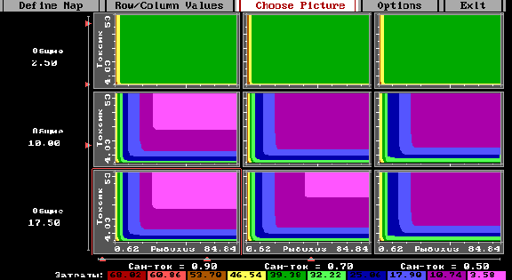
The value of the sanitarian indicator changes from column to column. The value of the toxicological indicator changes from row to row. This figure is a copy of the display of the system, and so the inscriptions are in Russian. The system was coded in DOS. For this reason the matrix consists of nine decision maps only. Any decision map is related to certain restrictions imposed on general pollution (values are given to the left of rows) and on sanitarian criterion (values are given under columns). Any decision map displays superimposed colored slices of feasible values of fishing degradation criterion given on horizontal axis, and toxicological criterion given on vertical axis. Colors are related to the cost of the strategy values of which are given the scale under the matrix. Cost is measured in millions of USSR rubles of the year 1989 (ten rubles were equal to about one dollar that time).
Comparing the decision maps for properly chosen restrictions imposed on general pollution and sanitarian criterion, environmental engineers understand influence of these criteria on decision maps and may select a preferable decision map. By this the values of row and column criteria are fixed. Then, a preferable goal may be identified on the decision map and the related strategy computed.
Let us consider an example. Though the river is quite polluted, the value of sanitarian criterion is sufficiently good in all columns. For this reason, the left column may be chosen. The matrix shows that a reasonable value of general pollution criterion may be achieved only if sufficiently large cost (green color) is applied. Let choose the decision map in the upper row given in the following Figure.
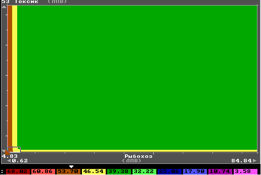
As one can see, the influence of additional cost on the efficient frontier of fishing degradation criterion and toxicological criterion are given without details in this figure. Since the IDM technique provides an opportunity to zoom a part of a decision map, it is possible to explore this influence in details. In the following Figure, a zoomed part of the decision map is given.
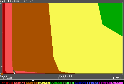
It is clear that the additional cost (yellow and brown colors) may be used for decrement of the fishing degradation criterion, but the toxicological criterion can not be improved substantially. It is clear that the marginal efficiency of investment falls (just compare decrement of fishing degradation due to change from green to yellow and from brown to red which are related to the same additional cost). The goal indicated by the arrow in the above Figure was chosen by environmental engineers. A related investment strategy was computed and displayed to environmental engineers in a specialized self-made Geographical Information System.
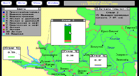
Examples of the GIS display are given in two Figures. Environmental outcomes of the strategy are displayed in the following Figure.
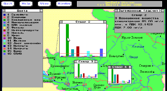
On the geographical map of the basin (this is the Klyazma river basin which is to the north-east from Moscow), the monitoring stations were given by small squares placed along the river and its inlets. To receive information about a particular monitoring station, one had to zoom the related square. The square related to the monitoring station number 2 was maximally zoomed in the Figure. It contains column diagram representing the concentrations of particular pollutants. The relation between color and the name of the pollutant is provided in the left corner. Concentrations are given in relative values: the recommended maximum concentration equals to one. The horizontal red line crossing the column diagram displays the recommended maximum concentration. The arrow points out one of the pollutants which has a high concentration. Detailed information on this pollutant is given in the box placed in the upper right corner: the name of pollutant (suspended staff in this case), its concentration in milligrams per liter, its concentration in relative units and the recommended maximum concentration. Zooming of squares related to the monitoring stations were provided by a mouse click.
The investment allocation is given in the geographical map displayed in the following Figure.
The information display has the same feature: one has first to zoom one of the squares. Here monitoring station number 2 is considered once again. This time the investment structure in the reach placed up to the monitoring station is given in the square. The total investment value is displayed above the column. The relation between colors and the names of the industries are given in the left corner. Here, the maximal investment volume in the reach is given by dark green color. It is pointed out by the arrow. The name of the industry (here the municipal water discharge) and the volume of investment are given in the box in the upper right corner.
Planning Support System
Let us now consider the computer-based system for supporting the water quality planning in river basins as a whole. The system consisted of five main subsystems:
- Data preparation subsystem;
- Subsystem for constructing the EPH;
- Subsystem for exploration of the EPH and identification of feasible goals;
- Subsystem for investment strategies computing;
- Subsystem for strategies display.